A County Boundary Is Not Always a Natural Edge
A county boundary can cross fields, roads and rivers without following a natural edge. Learn how to read the line and distinguish it from the landscape.
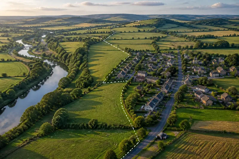
A county boundary can cross a field or divide a street without following any visible feature. A county boundary is an administrative line: it defines which area belongs to a particular unit of local government or geography. The hills, streams and settlements on either side may look much the same.
That distinction matters when reading a map. A line that appears to trace a river might follow it for a while, leave it at a bend, then continue across open ground. The river is a physical feature; the boundary is a rule represented on the map. Sometimes the two coincide, but one does not prove the other.
What does a county boundary define?
A county boundary marks the extent of a county as recognised for a particular administrative or mapping purpose. Its exact role depends on the country and the kind of county being shown. A map might depict a local-government county, a ceremonial or historic county, or a statistical area. Those categories need not share the same outline.
“County” is therefore not always a single, simple layer. In one place, a county may have an elected council and defined services. Elsewhere, a county may chiefly describe a historic region or ceremonial area. A map legend, publisher’s notes or the relevant local authority can clarify which sense is being used.
The boundary itself is not necessarily a fence, ditch or other feature that a walker can see. It may run through private land, across a built-up area or along an unmarked stretch of countryside. On the ground, people may have no reason to notice the point where one administrative area ends and another begins.
Does a county boundary follow a river?
Sometimes, but the map needs to show that relationship rather than invite an assumption. Rivers are conspicuous and can make convenient dividing lines. Yet a county boundary may use only part of a river, cross it, or pass nearby without following its channel.
Look closely at bends and crossings. If the boundary line stays beside the river through several turns, that is evidence of alignment in that section. If it cuts across a meander, leaves the valley or meets the river only at a crossing, the two lines differ there. A small-scale map can make nearby lines appear to coincide, so a more detailed map may help.
Even when a boundary follows a watercourse, the map may not tell you which bank defines the limit or how the line relates to changes in the channel. The representation can simplify a complicated feature. For ordinary map reading, it is enough to distinguish an apparent shared route from a proven legal description.
Why can a boundary cross hills, fields or settlements?
An administrative line is drawn to divide an area, not to describe a natural transition. It may pass over a ridge, through farmland or between adjoining houses because the division reflects the arrangement of local areas, responsibilities or inherited boundaries. The terrain does not have to change at the line.
Settlement patterns can make the division especially hard to see. A town may spread across a county boundary, leaving streets and shops on both sides. Neighbours may use the same school, station or high street while falling under different administrative arrangements. The boundary may affect which council serves an address, but it does not create a visible gap in the built environment.
Imagine a village whose newer homes have extended along a road towards a neighbouring county. On a local map, the houses form one continuous strip, while the county line crosses the fields behind them and meets the road near the edge of the village. The expected result is a clear distinction on the map between the administrative division and the settlement’s continuous physical form; the line need not mark where the village looks or feels different.
How can a map show whether the line follows a feature?
Start with the legend. Boundary symbols may be dashed, coloured or heavier than the lines used for roads and streams. The legend tells you which symbol represents the county boundary, while the base map shows physical features. Do not infer meaning from colour alone: publishers use different conventions.
Then compare the line with the terrain and built features at a useful scale. A topographic map can show contours, streams, roads and buildings alongside administrative divisions. A digital mapping service may let you switch boundary layers on and off, which makes it easier to see whether the county line bends with a river or crosses it.
- Check the map’s date and identify the type of county shown.
- Read the legend before treating a line as a boundary.
- Follow the county line through bends, junctions and crossings, rather than judging from one short section.
- Compare the line with streams, ridges, roads and settlement edges as separate features.
- Check a larger-scale map if two lines appear to overlap.
These checks help with interpretation, not with establishing a legal boundary for a property or official decision. Where the answer depends on a map’s date, the relevant authority, the map publisher’s notes or applicable local rules, consult the appropriate official source.
Why do different maps show different county lines?
Maps may be showing different county categories, using different dates or simplifying detail at different scales. One map might show a historic county outline; another might depict a current administrative area. Their lines can both be correct for their stated purposes while appearing to disagree.
Scale changes what can be shown. A regional map has limited room for minor bends and narrow features, so its boundary may look straighter than it does on a detailed map. A digital map can also combine information from different datasets, each with its own update schedule. Check the map’s description before treating a difference as an error.
Names can add another layer of confusion. Residents may use a county name to describe a broad area or a local identity even when their address lies outside the current administrative county bearing that name. Everyday usage is meaningful, but it is not a substitute for identifying the boundary type on a map.
Does a county boundary change what the landscape looks like?
No. The line does not create a different slope, soil or watercourse where it crosses the ground. It can separate administrative responsibilities, but the physical landscape may continue without interruption. A ridge remains a ridge, and a road remains a road on both sides.
It is still useful to ask why a boundary and a landform appear together. A ridge or stream may have been chosen as a convenient divider, or the two lines may simply meet in that section. A map alone can suggest a relationship, but it cannot always explain the reason for it. Describe what you can see first: for example, “the boundary follows the stream here, then crosses the valley”. That is more precise than saying the stream defines the whole county edge.
What should I check before describing a county edge?
Is this a current administrative boundary?
Check the map’s legend and description for the category it shows. If the map is intended to depict an older or ceremonial county, its outline may differ from the area used for current local administration.
Does the line actually follow the river?
Trace both lines through bends and crossings instead of assuming that proximity means alignment. A larger-scale map can reveal where a boundary leaves the watercourse.
Can a county line run through a town?
Yes. A built-up area can extend across an administrative boundary, and the street pattern may remain continuous. The line divides the mapped area, not necessarily the settlement’s visible form.
Which map is best for checking the line?
Use a map whose scale and stated purpose match your question. A topographic map helps compare the boundary with landforms and roads, while an official local-government source is more appropriate for identifying current administrative responsibilities.
A county boundary is best read as a line with a defined purpose, not as a prediction of what the land must look like. When you compare the boundary with rivers, ridges, roads and buildings separately, the map becomes easier to interpret. That simple distinction also makes descriptions more accurate: say what the line does in a particular place, and leave the landscape free to continue across it.